
IMRAY 100 - ATLANTIC CROSSING CHART
Product Number:
IMRAY100
Edition date: 2024 In stock
Edition date: 2024 In stock
SEK 405,00
Unitprice with VAT
Scale: 1:7,620,000 WGS 84
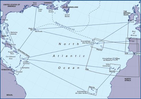
At a scale of 1:7,620,000 this chart covers the North Atlantic from Brazil to Newfoundland and Gibraltar to the Caribbean. It has been constructed on a conical projection that means that Great Circle tracks can be plotted as straight lines rather than curves.
The chart shows the main trend of contours, limits of ice, magnetic variations and keys routes as identified by DM Street. On the reverse are notes on the routes and small wind rose charts, with accompanying charts showing excessive wave heights and storm frequencies for the months that yachts cross the Atlantic: April to July and September to December.
Chart 100 is an important companion for Atlantic yachtsmen on passage and an excellent source of planning information.